• On Call  Service 24/7/365
  • BECOME A MEMBER
Tow Jamm
  • Chesapeake Bay, Kent & Knapps Narrows
    VHF Channel 16
  • Main Office (410) 745-3000
    BoatUS Dispatch (800) 391-4869

  • Marine towing
  • Marine salvage
  • weather
  • Home
  • Membership
    • Membership Benefits
    • Membership Plans
  • Dispatch Services
    • Boat Towing Services
    • Soft Ungroundings
    • Battery Jump
    • Fuel Delivery
    • Parts Delivery
    • Dock to Dock
    • Diver Services
  • Salvage & Wreck Removal
  • Resources
    • Charts & Links
    • Weather & Tides
    • Local Knowledge
  • About
    • Our Story
    • Our Crew
    • Our Fleet
    • Service Area
    • FAQ
  • Blog
  • On-Water Training
  • Contact

Blog

Navigational Hazard

3/15/2019

 
Hello all fellow boaters on the Eastern Shore of the Chesapeake Bay.  This is Capt. Adam with Tow Jamm Marine, TowBoatU.S Kent Narrows/Knapps Narrows.  I am coming to you today with a navigational hazard that last season caused damage to some vessels out on the water.   We wanted to bring this to your attention in order to help inform our fellow boaters of this hazard.
Poplar Island through the countless millennia of erosion had nearly disappeared.   An effort is being made to restore this island to its former glory. By using the dredge material from Baltimore Harbour and surrounding areas, they are recreating Poplar Island’s original size and structure.   The hazard that we are discussing today lies on the north end of the island. As the cranes and barges work, they create a rock retaining wall that outlines the shape and size of the final island. Once this retaining wall is built they backfill the lagoon that has been created  and an island is formed.
Picture

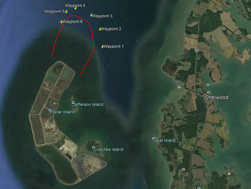
Due to the depth of the water, the retaining wall will be very wide and tall, coming out of the water almost 20ft.  Currently the retaining wall is only about 6ft out of the water. Last season the wall was less then 3 ft out of the water and at extreme high tides it was just at or below water line.   This season it is much higher but at night due to the rocks dark color it becomes almost impossible to see.


Today we put together a Geo-Perimeter Fence of GPS coordinates around Poplar Island north end.   I have overlaid this GEO-Fence onto a Google Earth Satellite image in order to help you understand how large this island protrudes to the North.   This image and these numbers are not to be used for navigational purposes, but are here to give you an idea of the hazard that exist. We recommend that you go to this area in good light and a calm day to see the amazing work they are doing out there.  This will allow you to enter your own GPS coordinates for a safe route around the island. Again we stress to never use the coordinates we are providing for navigational purposes. The coordinates we have given are only to show you the potential danger that exist. 

If you ever have a question about navigation, weather or hazards on the Eastern Shore of Maryland please give us a call at 410-745-3000 or call “TowBoatU.S.” on VHF channel 16 for help. And always remember: “The prudent navigator never relies solely on one form of navigation”      
  • Waypoint 1    38° 47.023'N 76° 21.390'W
  • Waypoint 2    38° 47.387'N 76° 21.366'W
  • Waypoint 3    38° 47.712'N 76° 21.515'W
  • Waypoint 4    38° 47.921'N 76° 21.882'W
  • Waypoint 5    38° 47.887'N 76° 22.128'W
  • Waypoint 6    38° 47.695'N 76° 22.292'W


Comments are closed.

    Archives

    November 2022
    September 2022
    May 2022
    April 2022
    March 2022
    February 2022
    January 2022
    November 2021
    October 2021
    September 2021
    August 2021
    June 2021
    May 2021
    April 2021
    March 2021
    January 2021
    November 2020
    September 2020
    August 2020
    June 2020
    May 2020
    April 2020
    March 2020
    February 2020
    January 2020
    December 2019
    November 2019
    September 2019
    August 2019
    July 2019
    June 2019
    March 2019

    Categories

    All
    Boating Tips
    Boat Safety
    Video

    RSS Feed


24 Hour Dispatch Services


Boat Towing Services
Soft Ungroundings
Battery Jumps
Fuel Delivery
Parts Delivery
Dock-To-Dock Towing
Diver Services
​

Salvage Services

Resources

Charts & Links
Weather & Tides
Local Knowledge
Find My Boats Location
BoatUS Service Locator

Download the BoatUS app

Picture
Picture

Weather & Tides

chester river-love point pier forecasts
Tow Jamm Marine Towing and Salvage
TowBoatU.S. Kent Narrows and Knapp Narrows
Main Office (410) 745-3000
BoatUS Dispatch (800) 391-4869

Tow Jamm Marine, Inc.
P.O Box 157
Neavitt, MD 21652
    QUESTIONS? THOUGHTS?
Jamm It!
© 2019 Tow Jamm Marine, Inc.

CALL
NOW